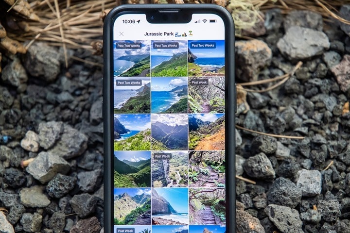
Strava has added the ability to see photos uploaded to the platform from other users to the route planning tools in their smartphone app. This means that if you use any of the route functions on the Strava app, you can see other geotagged photos in a new panel along with other route details. For those of you familiar with route planning platform Komoot, this will seem pretty familiar.
The idea being that you can better scope out the details of a route ahead of time by looking at actual photos, versus just satellite imagery taken from 800km above the earth. As one who often uses Komoot specifically for photos to cross-reference routes in new territory areas, this has the potential to be super interesting. In information provided to The Verge, Strava says that “the platform has roughly 2.3 million photos from 200 million user-uploaded public activities in the past year to pull from. It estimates that more than 30,000 photos will be added to the Routes feature weekly from Strava users all over the world.”
Now, before we start diving into some examples – some quick baselining:
A) Theoretically no pictures with faces will show up (but people from behind might)
B) Theoretically no pictures with “identifiable gear” will show up
C) It appears to only include photos from 2022/2023
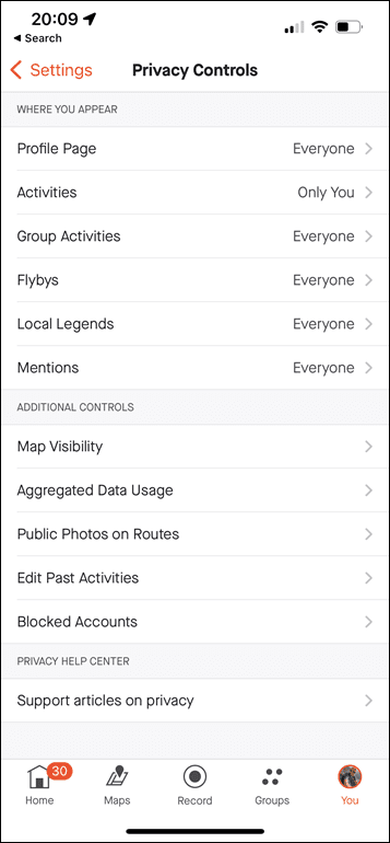
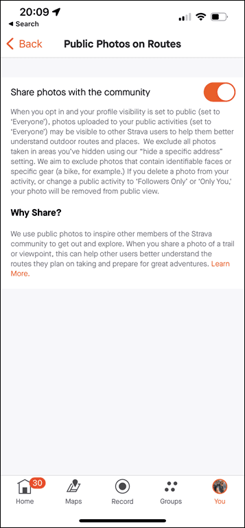
D) You can opt-out of this option in your settings (Settings > Privacy Controls > Public Photos on Routes)
E) Photos will not show from ANY Private activity or profile
F) It’s only available on the app at this time (not the website)
G) You need to be on at least app version 294
H) Only Strava-paid members can use the route planning tools, however, anyone can view existing routes (e.g. from someone else)
I) It does not show any photos taken inside one of your privacy zones (e.g. near your house)
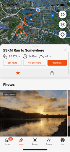
Got all that? Good, let’s get rolling. Last night I actually created a route for this morning’s long run. The purpose of creating this route was more about distance planning than exploring new lands. If I tap on the route, I see a new panel at the very top (above elevation) with the photos.
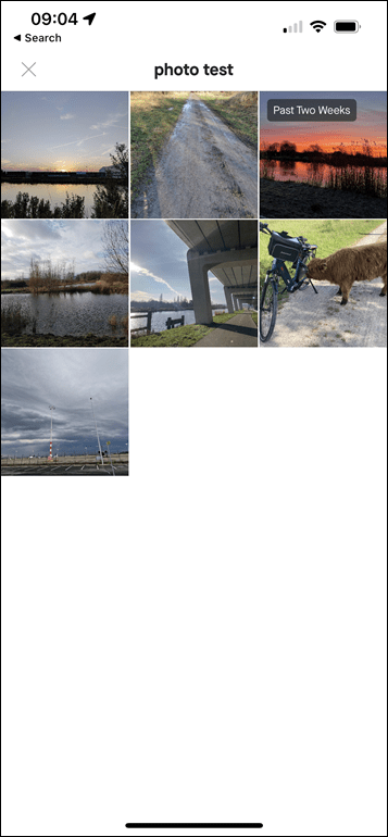
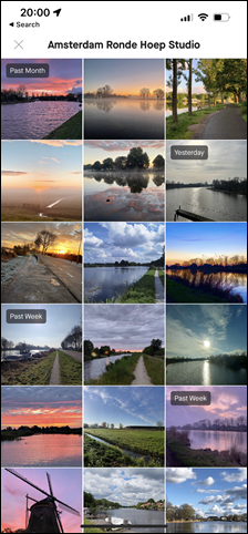
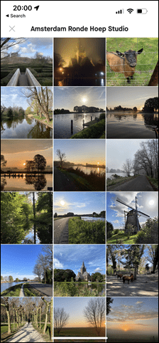
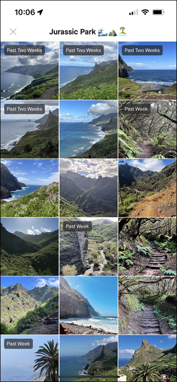
I can swipe left/right through the photos, tap on any individual photo for a bigger view, or, I can tap to see all photos along the route (up to 200 of them):
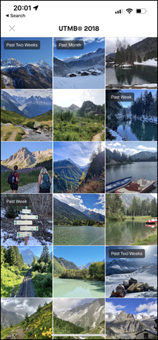
It’ll show a little tag if the photo was recent, including in the last two weeks. So, the question is, if I went out and ran that route, and added photos, would any of them show up in the collection? So yesterday morning, I then went out and ran said route, and added a smattering of photos taken along the way to my Strava activity upload today. In short, no, none did. In fact, I even narrowed it down to relatively specific mostly empty sections – and none of them showed up (even when Strava only offered just a couple other photos, one recent). I suspect there may be some sort of nightly process to pull these in, but as of 22 hours later, the photos aren’t showing up yet – which, is perfectly logical. I’ll check again tomorrow to see if any of my photos got pulled in.
As an aside, for some other nearby routes, I’ve seen some really stunning photos in here – it’s kinda impressive. I’m not sure if Strava is doing some sort of higher-level filtering to get rid of random junk, or if Strava users just take good photos. The same goes for up in the mountains (where it’s a bit easier to take interesting photos).
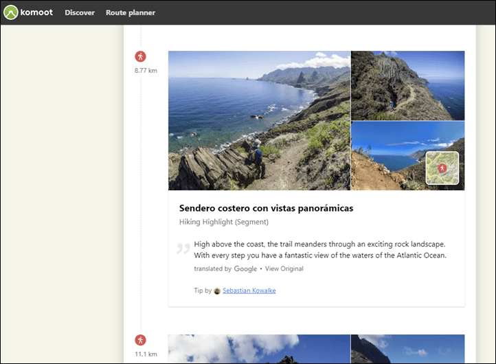
Next, let’s compare a trail/hiking route I did about a year ago (in the Canary Islands, Tenerife), where I very explicitly used Komoot ahead of time to try and figure out just how scenic the route was. In fact, it was so scenic I filmed my Garmin Epix In-Depth Review video from an amazing spot on the trail (check it out). In this case, no photos from my hike (from January 2022) showed up, which is fine, but plenty of others’ perfectly good ones did (85 in total).
Meanwhile, for that same route, Komoot also shows photos, but, it gives me the map sections these photos are on. Whereas Strava just gives me a giant bucket of all photos from the entire route, with no location information. Having the context on where the photo is taken is useful for perhaps picking certain chunks of a route (or avoiding certain chunks).
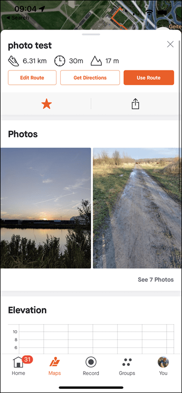
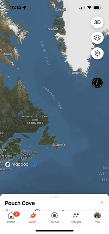
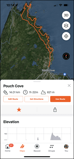
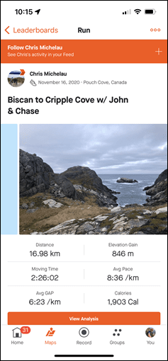
Next, let’s take a look at a route in an even less populated area – on the Canadian island of Newfoundland, where my wife grew up. I usually end up there once a year, and while there are plenty of people there – there are less on Strava, and even less uploading photos to Strava. Still, this is a popular route with trail runners in the area, and is maintained by a local trail society. Unfortunately, no photos showed up at all (middle screenshot below) – despite me being able to easily find photos in just the Top 10 leaderboard of a segment along the route (right screenshot below).
But in looking, the photos that did show up here were from 2020. And that’s when I realized it was limited to basically 2022/2023 photos only. I haven’t seen a single photo in any of the lists from 2021 or previous years. Perhaps they’re trying to limit things quality-wise, but in some lesser-visited regions, that’s also limiting their options considerably.
Now, there are really three main gaps I’d like to see addressed here:
A) Showing where the heck the photo was taken: Right now when I create a route (say 80KM), I have no idea where on that route the photos shown were taken. It just gives me a giant pile of photos. I’d really like to be able to tap on a photo and see (roughly) where it was taken. This would allow me to perhaps tweak routes with the best (or worst) parts taken into account.
B) Doesn’t show for segments: Totally understand that Strava had to start somewhere, but I’d like to see this exact same UI shown on the Segment panel. That’d be great, and really help with both hyper-specific route sections, as well as just checking out segments individually from a competition standpoint.
C) Show older photos: I’m not saying I need to see photos from 2013 (maybe…), but I think 2020 photos are still totally valid here, and would fill in the gaps in less populous places.
Inversely, I do like:
A) The tag showing “last two weeks” and “last month” tags on photos
B) Either Strava users take really damn good photos, or Strava seems to be adding some logic to pick the nicest photos (using whatever algorithm they have). I’m mildly astounded at how good some of these photos are (not resolution-wise, but composition, lighting, etc…)
C) The overall presentation is pretty good here, super easy to find, and not buried deep somewhere.
Finally, if you want to turn this off, you can do so under the settings (Settings > Privacy Controls > Public Photos on Routes):
Overall, it’s a good addition, and with a few minor tweaks could be even more useful. Of course, it’s worth pointing out though that if converting subscribers is the goal, then Strava just added yet another feature to the free tier – giving less of a reason to pay the subscription fee. At some point, Strava has to decide what their subscription strategy is. Thus, even when they do cool tech things – that doesn’t seem to be aligned with whatever the business strategy is.
Speaking of which, as a casual reminder, Strava still hasn’t sent an e-mail out about their price increases. Peloton did, TrainerRoad did, TrainingPeaks did, and just yesterday, Whoop even sent out an e-mail about price decreases. Still waiting…
With that – thanks for reading!
FOUND THIS POST USEFUL? SUPPORT THE SITE!
Hopefully, you found this post useful. The website is really a labor of love, so please consider becoming a DC RAINMAKER Supporter. This gets you an ad-free experience, and access to our (mostly) bi-monthly behind-the-scenes video series of “Shed Talkin’”.
Support DCRainMaker - Shop on Amazon
Otherwise, perhaps consider using the below link if shopping on Amazon. As an Amazon Associate, I earn from qualifying purchases. It doesn’t cost you anything extra, but your purchases help support this website a lot. It could simply be buying toilet paper, or this pizza oven we use and love.

![clip_image001[6] clip_image001[6]](https://media.dcrainmaker.com/images/2023/02/clip_image0016_thumb-1.png)
![clip_image001[8] clip_image001[8]](https://media.dcrainmaker.com/images/2023/02/clip_image0018_thumb-2.png)


Very interesting feature, well once we can see where the photo is from on the route map. Until that functionality is enabled it’s next to useless for planning anything over a few kilometers imo.
It would also be useful for Strava to say how long it takes to view uploaded photos on the route planner and I also agree, there is nothing wrong with pulling photos back to 2020 and perhaps further back for areas that have limited photos.
As for releasing this for free. I assume this is some form of damage control, after the pricing debacle.
I’m probably being dumb but what makes it a better alternative to Google Streetview?
Two core things:
1) The first being that while Streetview is good for streets, it’s typically less good for non-streets – namely tralis. Obviously, Google does a good job if you have things like viewpoints/etc (e.g. hiking to a summit), but beyond that it’s kinda hit or miss
2) The second, even for road, just being having to switch back and forth between tools. While some readers of this site (including myself) might be fine doing that, it’s overall cumbersome for quick route planning, especially in places you don’t know well or can’t even read/say/spell the street names (e.g. a foreign country).
Beyond that, I think there’s also a reality that native Streetview (taken from car/bike/person) tends to be focused on the view from the actual street (e.g. a drivers view). Versus photos taken by people uploading to Strava, tend to be focused more on the scenic elements of that ride – what you as a cyclist/hiker/etc are looking at as you burn away the hours.
Both have pros and cons of course, but I think with some minor tweaks this could be a super powerful tool given the quantity of photos uploaded. Also, I think it might encourage people to add more photos to their Strava uploads. For example, on yesterday’s run, I added a bunch of semi-random photos I might not normally have added into the pile. None of them were bad photos, but just photos of spots along the way (to see if they’d show up later). Contextually those could be useful to someone else down the road.
If the photos were geotagged, and with the info on recent or not, I would totally use this to consider what condition my local trails are in during the winter. They get really muddy. So trails in general and specifically recent – street view would miss both.
RidewithGPS’s route planner has Streetview built in. Which is one of the many ways it’s vastly better than Strava’s offering.
Trailforks has been doing this for years, at least on a trail (segment) level.
Yup, good point! Albeit, I find it pretty slim overall on photos. Many times you’re lucky if you get one photo.
It’s mildly frustrating how app-first Strava is acting. I just can’t imagine ever wanting to plan routes on my phone. Similar to how I didn’t understand the workflow for uploading edited videos through your phone for some reason? But at least they eventually added that to the web version, so fingers crossed this gets ported over as well.
Anyway, can’t say much else as this feature doesn’t seem available to me at this point, even on app version 294. Tried both local (Denmark) routes and touristy routes in various locations.
For fun, try restarting the app (force close it out and open again). Here’s two routes that should show photos:
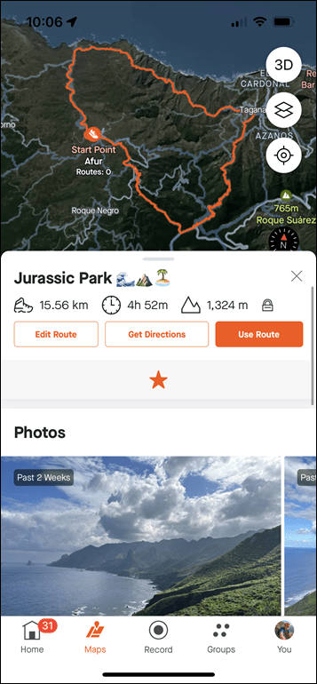
Titled Jurassic route above:
link to strava.com
My long-run yesterday:
link to strava.com
Your links work for me. When I use one of my own routes from Profile->Routes (how I would normally look at my routes), though, I have to create a URL and then click on it for photos to appear, which in effect switches to Maps. There doesn’t seem to be UI in my Profile->Routes to see photos. I see them under Maps->Saved Routes
Huh, odd. For me, any place I access a route it shows it:
A) On autogenerated routes (after clicking ‘See Details’)
B) On my own saved routes (after clicking ‘See Details’)
C) And a soon as I save a route after clicking ‘Draw your own Route’
All of these are under the ‘Maps’ tab at the bottom, then ‘Routes’ or ‘Saved’ tabs above that.
Interestingly no photos for me on either route you linked in the US – app version is 294.0.0.
Agreed. Maybe I’m just old (in my late 30s), but I cannot imagine trying to plan a route on my phone.
Your Jurassic route showed pictures but nothing I’ve pulled up on my own has.
So I’ve had a chance to look at a bunch of the routes I’ve generated over the last few years through Maps->Saved Routes. Some of them have pictures, most of them don’t. On the routes that do have pictures, a lot are just repeats of pictures of the same landmark that’s on multiple routes.
I tracked down a ride I did in 2022 for which I have a route and uploaded pictures (whether I actually navigated it or not on my 830 I don’t remember, since I’ve done this same ride many times over the years). Here’s the ride and here’s the route. The only pictures I see on my phone attached to the route are of Bear Meadows, a landmark on the way back (not a meadow, and usually no bears; it’s a remnant bog from the period of the last Ice Age). None of the four pictures I uploaded for the ride are there. So I guess this is still a work in progress?
Some part of that functionality must be free for all. Otherwise why should I stay opted in for using my photos if only paid users take advantage…
Because paid users subsidize the free users, so you can at least give them something in return? :)
Probably more likely that a lot of people wouldn’t bother changing it. If someone is really privacy worried they’ll turn it off no matter what. If someone isn’t worried, they may not care enough to “stick it” to Strava for not including it in the free version
Probably user error but I have version 294.0.0 and I’ve yet to find photos on any of the routes I’ve checked. Is it possible there are some additional revisions required beyond just 294?
Supposedly that’s all that’s needed. Try closing out and re-opening Strava (force kill it), and see if that does the trick. It’s open to all members per their FAQ: link to support.strava.com
Force Closed and I’m a premium member. Still doesn’t appear to work.
I really wish they would stop having app versus website differences. Planning route on the app is marginal, maybe that is the reason they added it, but I’m sure the majority of route planning happens at home on a computer or tablet.
Then there are things that show on the Web but not the app. Most important, a route shared within Strava shows in the notifications on the web but doesn’t show up anywhere in the app.
Almost seems like there are two teams that don’t work together when it comes to new features planning
Once again a US company ignoring privacy laws of the rest of the world. This should have been opt in, it’s a simple concept, why is it so frickin’ hard?
While I agree with opt-in in general, I’m pretty sure their terms/conditions already note that if you’ve uploaded photos to a public activity (not private/etc), those photos are fully visible across the platform. Previously/currently when you attached a photo it showed the exact location on your activity map (again on a public activity), but it doesn’t even show that here.
These aren’t private photos, photos in privacy zones, photos of peoples faces (or even backsides in almost all cases), etc….
A very American attitude (which figures, I guess!). Terms and conditions might be enforceable in the US but elsewhere they don’t override the law and constitute an unfair contract.
Having my photos publically accessible is different to my pictures being monetised and published for gain by the company, and I would certainly not opt in to this without some form of compensation. I am not the product here, I am a paying customer.
Totally agree
I am an American who is not a lawyer, but I don’t see a big issue here, honestly. Strava users who add photos to public posts are sending their image data to Strava and asking Strava to share it with the platform. Why would you make a public post if you don’t want the public to see it? The option to restrict sharing already exists the activity level as well as the account level. The option to not post the photo also exists. The images are not monetized [yet?]; they are viewable free to charge, no subscription required. Strava is just sharing it in a new way, and on top of all that, you can opt-out of this new way.
I will say that they can do both themselves and their users a favor by sending an email introducing the new feature and mentioning the opt-out toggle.
There isn’t a big issue under American law, that’s why I called it out as it massively skews the perception of the issue. In other locations around the world, mostly EU and Commonwealth countries, we have stronger consumer and privacy protections in place.
Just because I upload my data for one purpose doesn’t mean Strava (or any other company, for that matter) own it and can use it for another purpose. This is very clear in the law, and they need to seek additional and specific permission on an opt-in basis for new uses of our data. Ray uploads content to YouTube, do we think it’s cool for YouTube to take that content and sell it to TV stations? Same exact issue, and no doubt in the US they might pull it off with enough spending on lawyers.
You may now be thinking “ah but terms and conditions say….” and you’d be wrong again. As far as I can tell, only the US legal system allows for such contracts to be binding. Elsewhere they are unenforceable as unfair contract terms, and because we didn’t agree to them explicitely (clicking OK does not constitute acceptance of a contract in most of the world).
Dave, you wrote “Ray uploads content to YouTube, do we think it’s cool for YouTube to take that content and sell it to TV stations? Same exact issue”
That sounds like a very different issue. In that case, the content would be sold and distributed outside of the original platform. Strava is doing neither of those things. They have just added a new way for Strava users to discover content which, again, has already been shared with all Strava users. As an aside, I doubt Ray would mind if YouTube created a feature that brought his videos to the attention of larger set of YouTube viewers.
You also write “Just because I upload my data for one purpose doesn’t mean Strava (or any other company, for that matter) own it and can use it for another purpose.”
OK, but what is the purpose of publicly posting a dated, geotagged photo on Strava, if not to share that photo with the Strava community? Strava’s photo feature facilitates that sharing. If public sharing is not intended, the user should set their privacy settings accordingly.
It’s not different at all. Strava are monetising that content without my consent, simples.
The purpose of posting photos on Strava is for my friends to see the ride. Strava provide a platform to let me socially post my activity to my friend group. Even if I set the ride to public, it’s so that people who are not my friends can see my specific ride. The photos remain my copyright material and intellectual property.
Strava are now also trying to take my content and use it to provide another service to their entire user base. This is materially very different indeed, and requires that they collate and process all of the images for that new purpose. They have offered me no compensation for using my IP here, nor have I agreed to licence it to them for this purpose. Quite the opposite, they just offered to charge me more for my premium membership (I declined!).
As I said, it’s a culture thing. Some countries protect consumers and personal data, and some countries are set up to screw consumers and personal data for as much profit as possible. The problem comes when that one abusive country has businesses which operate globally yet don’t respect the laws of the regions in which they operate. It’s not a debate, by the way, it’s the law. Your personal feelings on it are irrelevant.
Not debating, but which exact/specific law requires that (EU or UK)? Specifically, requires that they re-acquire permission for something new/different?
I ask because their terms of service explicitly call out plenty of uses, and as a user one agreed to these. Those terms actually don’t delineate how precisely Strava uses your photo, other than they they can in a billion ways. So when you initially agreed, you basically agreed to anything. Monetization hasn’t changed here from what you first uploaded.
The ToS are not a valid contract outside of the US so while Strava may dream that anything and everything they say is valid, it isn’t. This is considered an unfair contract and would be thrown out in court. The manner of agreement to the ToS is also invalid in many jurisdictions since it’s a take it or leave it offer and agreement is required to move on in the process. Many companies have fallen foul of this basic contract law including a certain global tech company who used to put the EULA inside the plastic and then moved it to software.
There are various laws covering these scenarios including GDPR as one of the most prominent covering use of data. Most photos contain sufficient PII to be covered by this as I’m sure you’re aware. Copyright law (which works differently outside of the US) also covers it, as would IP licensing since no contract is in place for them to use the content aside from that explicitly agreed by the content owner.
As I said above, you gave YouTube permission to share your videos on their platform, but that doesn’t entitle them to slap it on a “DCRainmaker 2022 compilation DVD” and sell it in the local supermarkets. Even if they said they intend to in the ToS you would still likely win against them in court in the Netherlands if they tried. Not necessarily so in the US where the lawyers roam free…
I’m certainly not going to argue EU law, but I don’t think your analogy is close here (either the TV station of DVD sale). Strava isn’t directly selling the content, just making it available to their users in another place. If you have a public instagram account (not one that requires accepting followers) and you post a photo and it shows up on your page on people’s feeds, this is the equivalent of instagram adding their search/suggestions page and having a photo also show up there.
Separately, Ray – is it possible that pre-2021 photos are currently excluded because they changed the terms of service and their lawyers decided photos loaded prior to a certain term update couldn’t be included without permission? (In the US at least)
I knows it been said, but I can’t imagine panning a 100 mile ride on my phone. ALL my routes I have EVER made that are longer than 5 miles are done on my computer. It’s the routing feature that keeps me a paid subscriber. I hope they role this out to the web based version if not, it’s just a feature that I could care less about.
The good news:
The web route builder and the app route builder have the same photo functionality.
The bad news:
That functionality is “nada”. The photos (stripped of their geotags for some reason) are only visible when viewing an existing route, and only in the app.
Hopefully photos are added to the route builder at some point.
You should try Komoot then. The app interface for route building is really good and makes it easy to build even really long routes. It doesn’t have the traffic data that Strava has but it makes up with other functionality.
Will do, thanks.
I love that feature, will take my sub back if they are plotting the pictures along the way a la komoot
Unless I’m missing something, photos are only visible after a route has been created, so it’s not at all useful for creating routes.
It may be useful for selecting a route, but in the current form, I don’t think it does much besides “jazz up” the route details card on the app.
A photos layer on the route builder map would be great, as it would supplement to surface type indicators that Strava has already and also to Google Streetview.
I have actually tried to use Strava photos in route planning before, to figure out if a stretch of “dirt” could be included on an upcoming road bike ride. I found a segment that overlapped the supposed road, scrolled down to leaderboard, and clicked on a million of the listed rides until one of them had geotagged photos showing the road surface. Streetview is the obvious choice for this kind of thing, but the Streetview drivers seem pretty reluctant to drive on long unpaved roads in the middle of nowhere, at least in my region. Can’t say I blame them.
Hopefully a photo layer in the route builder is in the works.
Pedantic correction – the satellite imagery used in the kind of mapping that we are used to (google maps, strava, etc) isn’t taken from geostationary orbit. That’s just too far away, and even if high enough resolution and zoom levels were available it’s above a fixed point so all of the images get skewed the further away from that fixed point on the ground they are. Most widely used satellite imagery comes from much lower orbit – typically something like the modern Landsat series, which orbits at something like 705 km.
I was about to write the same comment.
Actually, when you zoom in to the lower levels, the pictures are taken from aircraft.
See link to linkedin.com
Notice the aircraft in logo. They also say they have 10 aircraft fleet… This for EU pictures.
Good catch on height.
As for zooming in, that’s true, but it really depends on the area. The vast majority of the earth is not covered by aircraft imagery. Really only the higher-population areas.
As an aside, it’s fun to watch the Aerodata aircraft do their sweeps via something light FlightAware24 or such. Here’s one from this past weekend doing sweeps: link to flightaware.com
You can see just how long it took (nearly 4 hours) to really only get a very small slice of things. Toggle on the ‘Replay’ then tap 50x.
I’m now agreed with 50 EUR/month
Hey DC, thanks for sharing. As a little note, satellite data (for maps as you mention) doesn’t come from a geostationary orbit and most often comes from a sun-synchronous orbit that is far closer to the earth ~ 600-800km altitude. It’s primarily weather and communication satellites that occupy geostationary orbits.
Thanks Steve – good catch!
Maybe mentioned already, but why not offer credits to users that take good trail/route appropriate photos. Strava could look at a segment and pick a good photo of a key part (decided by gradient or similar) then give the user a dollar or euro credit off next years subscription.
Make it something that doesn’t require an extreme V02 or KOM. Instead something that is for the love of the ride/run/hike/etc.
Maybe not so popular with the bean counters though…
Oh and sure you know, but not all google satellite imagery is for taken from 35,786km above the earth, some from planes too.
link to support.google.com
“E) Photos will not show from ANY Private activity or profile”
should be “any non-public” activity, since there is a “followers only” middle mode. also, do private profiles include profiles with public activities that you have to request to follow? strava privacy controls are a bit all over the place.