This product has been discontinued by the manufacturer. It's been replaced by the Hammerhead Karoo 3, you may want to check out that review instead.
I’m DC RAINMAKER…

I swim, bike and run. Then, I come here and write about my adventures. It’s as simple as that. Most of the time. If you’re new around these parts, here’s the long version of my story.

You'll support the site, and get ad-free DCR! Plus, you'll be more awesome. Click above for all the details. Oh, and you can sign-up for the newsletter here!
Here’s how to save!
Wanna save some cash and support the site? These companies help support the site! With Backcountry.com or Competitive Cyclist with either the coupon code DCRAINMAKER for first time users saving 15% on applicable products.
You can also pick-up tons of gear at REI via these links, which is a long-time supporter as well:Alternatively, for everything else on the planet, simply buy your goods from Amazon via the link below and I get a tiny bit back as an Amazon Associate. No cost to you, easy as pie!
You can use the above link for any Amazon country and it (should) automatically redirect to your local Amazon site.
While I don't partner with many companies, there's a few that I love, and support the site. Full details!

Want to compare the features of each product, down to the nitty-gritty? No problem, the product comparison data is constantly updated with new products and new features added to old products!

Wanna create comparison chart graphs just like I do for GPS, heart rate, power meters and more? No problem, here's the platform I use - you can too!

Think my written reviews are deep? You should check out my videos. I take things to a whole new level of interactive depth!

Smart Trainers Buyers Guide: Looking at a smart trainer this winter? I cover all the units to buy (and avoid) for indoor training. The good, the bad, and the ugly.
-
Check out my weekly podcast - with DesFit, which is packed with both gadget and non-gadget goodness!

Get all your awesome DC Rainmaker gear here!
FAQ’s
I have built an extensive list of my most frequently asked questions. Below are the most popular.
- Do you have a privacy policy posted?
- Why haven’t you yet released a review for XYZ product you mentioned months ago?
- Will you test our product before release?
- Are you willing to review or test beta products?
- Which trainer should I buy?
- Which GPS watch should I buy?
- I’m headed to Paris – what do you recommend for training or sightseeing?
- I’m headed to Washington DC – what do you recommend for training?
- I’m from out of the country and will be visiting the US, what’s the best triathlon shop in city XYZ?
- What kind of camera do you use?
-
5 Easy Steps To The Site
In Depth Product Reviews
You probably stumbled upon here looking for a review of a sports gadget. If you’re trying to decide which unit to buy – check out my in-depth reviews section. Some reviews are over 60 pages long when printed out, with hundreds of photos! I aim to leave no stone unturned.
Read My Sports Gadget Recommendations.
Here’s my most recent GPS watch guide here, and cycling GPS computers here. Plus there are smart trainers here, all in these guides cover almost every category of sports gadgets out there. Looking for the equipment I use day-to-day? I also just put together my complete ‘Gear I Use’ equipment list, from swim to bike to run and everything in between (plus a few extra things). And to compliment that, here’s The Girl’s (my wife’s) list. Enjoy, and thanks for stopping by!
Have some fun in the travel section.
I travel a fair bit, both for work and for fun. Here’s a bunch of random trip reports and daily trip-logs that I’ve put together and posted. I’ve sorted it all by world geography, in an attempt to make it easy to figure out where I’ve been.
My Photography Gear: The Cameras/Drones/Action Cams I Use Daily
The most common question I receive outside of the “what’s the best GPS watch for me” variant, are photography-esq based. So in efforts to combat the amount of emails I need to sort through on a daily basis, I’ve complied this “My Photography Gear” post for your curious minds (including drones & action cams!)! It’s a nice break from the day-to-day sports-tech talk, and I hope you get something out of it!
The Swim/Bike/Run Gear I Use List
Many readers stumble into my website in search of information on the latest and greatest sports tech products. But at the end of the day, you might just be wondering “What does Ray use when not testing new products?”. So here is the most up to date list of products I like and fit the bill for me and my training needs best! DC Rainmaker 2024 swim, bike, run, and general gear list. But wait, are you a female and feel like these things might not apply to you? If that’s the case (but certainly not saying my choices aren’t good for women), and you just want to see a different gear junkies “picks”, check out The Girl’s Gear Guide too.




What are the chances Garmin gets smart and adds this feature to their Edge line?
I’d be surprised if it doesn’t become the norm for all competitive bike computers over time. Hammerhead is simply raising the baseline bar.
Wahoo bolt owner
I’m curious as to what it does when you start a climb but then arrive at an intersection and turn off the climb early. What with one climb in the area I guess Ray can’t test for that. Until they install a mind reader, there’s no way for the Karoo to know exactly where you intend to go, which is why the course was required in the past.
My understanding is it simply ends the climb screen.
That’d make sense, but that means that a lot of the information they’re showing is irrelevant (distance to top, gradient after the intersection). Still, I suppose the gradient during the portion of the climb you’re actually doing would be useful (if it was accurate, that is). I’d guess Garmin does something like this soon, but I’m not sure if I’ll actually like it.
yes karoo can’t know where we will go for sure
1. how often do you turn off half way up a hill? Sometimes, no doubt, but more often than not you go to the top
2. garmin might be able to predict you will turn somewhere if you always turn there (personal popularity data), maybe karoo can do this too but if you’ve done that route a lot then surely you know the hill and the turn?
3. garmin might be able to predict you will turn somewhere if everyone always turns there (popularity data)
K2 got a good hill prediction for me last week in the scenario where the road (number) I was on turned right and went flat. yet it somehow worked out i was going straight on (onto a differently numbered lane) up the hill.
firmware: 1.279.1168.12
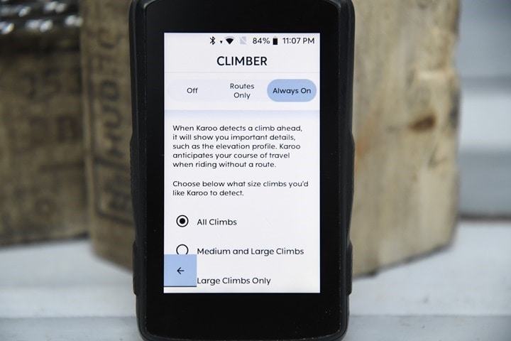
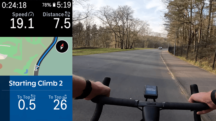
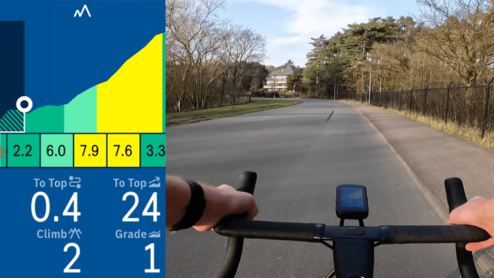
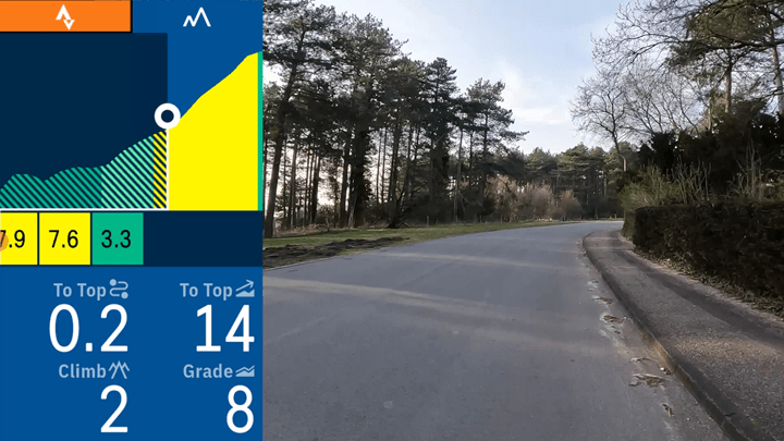
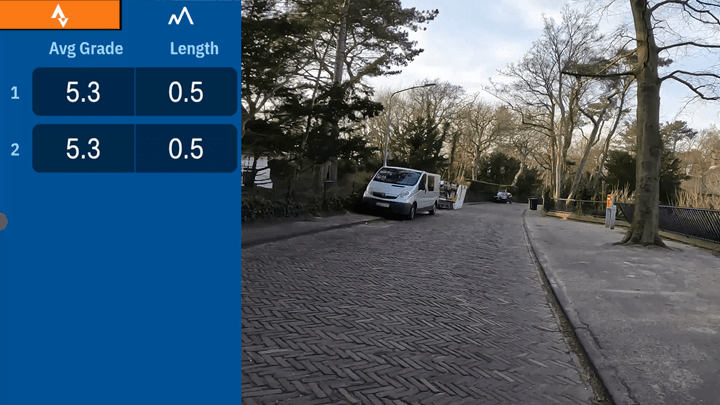
CLIMBER Without a Route looks at the upcoming segments of road and calculates climbs up to the next major intersection*S*. If the current ROAD NAME remains consistent and/or you are able to continue essentially “straight” on the road, it will analyze that potential route. If you deviate from that predicted route (eg, turn off of the road when CLIMBER predicted straight), CLIMBER will analyze the new road to the next major intersection.
After a few seconds it notices you’re off the predicted climb and ends the CLIMBER overlay. It handles it nicely.
I wouldn’t even call absence of a mind reader a missing feature: the “what if I’d stay on this road” is just as much an interesting tidbit of data as most of the other stuff we have on our screens. Bonus points of course if they do mark major intersections/bailout opportunities in the profile, so that you’d know for example how far and high to Lautaret while it (hopefully!) displays Galibier.
Very nice feature indeed. Have been impressed overall with my K2. Look forward to the day I don’t have to wear my chunky Garmin Fenix to get TyreWiz numbers..
Curious which version firmware you are running? I’m on 1.279.1168 and it says it’s the latest version, and this is confirmed by Hammerhead’s firmware update page.
Hammerhead hasn’t even listed this update on their software release page. Give them a few hours.. Ray def got some inside peeps
This is great. I have a few big climbing events on the calendar this year (Triple Bypass in Colorado and the Horribly Hilly Hundreds in Wisconsin). Plugging in the routes and turning on navigation just to get the Climbr feature is such a big battery suck which has already lead to the Karoo dying early on one of these type of rides.
I’m hoping riding w/o navigation with Climbr still enabled means better battery life.
I have this same question – need to go out and try this weekend I guess. I REALLY like climber, but don’t like the 5 hour battery life I see when using it – that just isn’t enough for slow me. I too hope this may help? I’m curious to see how that plays out.
It’s Android baby, It’s Android (c)
No inside info on this one (I don’t even have the devices in question) however, I would assume this new ability is going to definitely require more battery than not having it enabled. It must do most of the same things as the normal routing features (process a local map loaded in the system while comparing topographical changes to GPS location)… that activity (plus constant screen updates) is likely what is killing the battery, actually “following/navigating” a route, after having to do all the above for EITHER method, is trivial additional overhead at that point (I’d almost argue the non-route would be more CPU intensive as it has to predict the route, rather than knowing “I’m going from here, to here, here is the elevation profile in that segment”, now it has to figure out “you are most likely going from A to F, skipping options C,D,E (side roads for instance) as they dont’ appear as likely to be used (based on whatever algorithm” so here is the elevation profile”…
In other words, battery is gonna probably suck equally as much without a route loaded, as with, maybe even worse…
Very interesting. What happens if the path with the climb splits after 200 meters into 2 paths with different climbs? Is the current climb only shown up to the split and then a new climb is shown (I hope the question is understandable)?
For grins, the next time you head out on a weekend when parking use is minimal, what happens if you ride up something like this?
A security guard apparates and yells at you?
Ray: could I ask what train you used to take to get to skyline drive for your rides? I’ll be back in DC over the summer and looking to do some rides in the mountains, but won’t have a car. Thanks! Alan
Not a lot of train options in US in terms of schedules and bicycles:
link to amtrak.com
Only viable option from DC would be spending a long weekend in Charlottesville or Roanoke VA.
Trains arrive at night and leave in the morning. See schedule for Crescent or Northeast Regional lines.
25 miles west of Charlottesville at Rockfish Gap is Skyline Drive (headed north) or Blue Ridge Parkway (headed south). Just getting there and back would be 50+ miles if staying in C’ville.
The Parkway passes through Roanoke which offer lots of rural climbing loops besides Parkway sections.
A year or so from now the train may stop in Bedford VA, home of TP/Hunter Allen/PCG. Similar routes to Roanoke. link to visitroanokeva.com
Those train rides from DC would be 3-5 hours on their own. For day tripping out of DC you can likely hook up with the local cycling group and find challenging countryside routes a lot closer to the city.
Indeed, unfortunately in my case I used a car then. I’d drive to the entry gates of Shenendoah National Park, and go from there.
This has been my number one wished-for feature on my Garmin edge. I rarely create a route before I head out, preferring to simply explore after looking at a map before kicking off. As a result I’ve never really benefited from all the climbing features.
Hopefully this comes to Garmin and then to existing edge units.
I record my rides with my FR945 LTE but still have my old Edge 520 on my handlebars as it’s easier to see. This would make me upgrade to an Edge 540 and also make me reconsider my premium strava subscription.
This is really cool. Very impressed with how they are pushing out great new features. I’m a big Wahoo fan and disappointed they don’t have anything close to this. :-(
Did you post this ride to Strava? I’m going to Amsterdam in a month and will be there for 6 months. I want to do this massive climb. :-)
Not sure if I’m missing the joke, but it’s called “CLIMBER” (not “CLIMBR”) right?
> “CLIMBER” (not “CLIMBR”) right?
Wahoovirus attack
Haha…true…good catch!
(I am in DC also) I almost never create a route, so I never get to see climbpro on Garmin, which is annoying. Garmin really needs to add this.
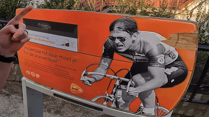
Now don’t be slagging on Gerrie Knetemann! He was a great Dutch racer BITD.
Meanwhile Wahoo is rolling out another “bug fixes and performance improvements” update that doesn’t do anything, for the 27th time over the past year. Time to switch head units?
I actually do NOT like ClimbPro when navigating a route (because I want to stay on the map), but I would like to have it when simply riding in known territory without a route loaded. There are many nice hills here and I am always trying to remember the altitude to climb out of my head…
agree … I think we need more control of profile data instead of just a climb feature. I especially agree regarding display of map and profile info concurrently. It’s not like climbs have no intersections.
That’s exactly what i need for garmin climbpro ! I usually ride to my ‘climb park’ and then i choose a combination of the same 2 or 3 climbs to reach my goal.
I loaded the new SW onto my Hammerhead today before my commute home and WHOAH! This is so cool. I’m really glad that I picked this head unit up. I can’t see myself ever going back to Wahoo or Garmin.
I’m not a K1/2 owner (yet), still on an Edge 530, although I am on Hammerhead’s email list. I just received my email informing me of the “All New Predictive Path Technology”, only on Hammerhead. Yeah, this is a feature I would enjoy for fun. I rarely know which hills I’ll be climbing when I set out on my long rides. I have all my climbs of interest as Live segments so I can get climb stats without having to preload a route.
It would be interesting to know what their hill route predictive logic is (assume the “main road” at a fork? compare against some popularity heat map? mind reading?). I have noticed that my Edge 530 will inform me of sharp curves ahead even when I am NOT following a pre-loaded route. Not sure of this logic either, but it is obviously “aware” of the road I am on. This feature is also triggered by speed, meaning that if I go up a sharp hairpin at 5mph, I will not get a warning. But if I go down it faster, I will get the warning. I haven’t fixated on it enough to try to figure out what the speed threshold is, or even if maybe it is knowledgeable that I am going “up” in a sharp turn, so it figures a high-speed crash shouldn’t be a problem (I guess I could take an e-bike up a climb as see if it’s speed or descent/ascent triggered).
Regarding discovered climbs by either the 530 or the K2, I’ve noticed that the accuracy on the 530 of the “end of the climb” increases when the true summit is more abrupt. Discovered climbs that gradually start rounding off before the geological summit are much less accurate, always ending before the true summit. This isn’t surprising given the climb definition parameters. Including the top of gradually rounding summits often disqualifies the climb per the parameters, so to qualify as a climb, the flatter end of the climber gets lopped off. So I guess technically, what the head unit is indicating is that “you are now on an incline that is at least 500 meters long and averages at least 3%”.
And a final question for K2 users, when this new predictive climb feature triggers and most of the climb coincides with a Live Segment, can you page between the K2 discovered climb and the LS?
You sure can. The ‘drawer’ allows you to swipe left/right between a few tabs such as phone notifications, lap data, climber, SLS, etc…
Ps: the ‘drawer’ is what pops up when the climber appears or a text/email, etc…
Thanks. That’s great. The K2 will definitely be my next head unit.
I’d be happy if the the slope on my Garmin reflected the actual current slope, vs. being several seconds behind.
If you climb slowly like me, your display and actual values will be the same. 😉
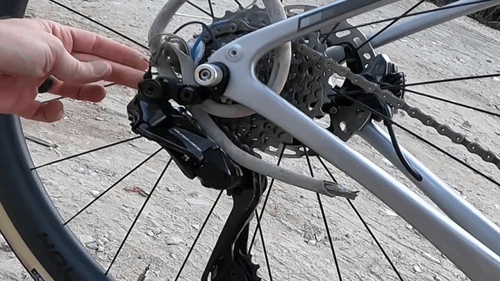
Love the photo of what Di2 would have looked like if it had been around in the 1980s, no doubt running on 2 D-cell batteries that needed replacing every two hours.
Awesome update, thanks for sharing!
Is there a way to set priority between climber and Strava live segments? Seems to default to climber, I would like to default Strava if I can…
You mention that it must be 400 meters to count as a climb. Any gradient requirement?
For Garmin it seems to be 500 meters AND 3% AND 1500 if you multiply the 2.
Why not make this configurable?
I get the 1500 multiplied, but I want to lower or completely drop the 500 and 3 requirement, so you can have:
300 meters and 5%
1000 meter and 1,5%
And maybe even
150 meters and 10%
1500 meters and 1%
Anyways. Does not matter much, is Garmin dont replicate this feature
I was thinking about these climber functions on my rides over the weekend. One route was largely new roads with >2000m climbing and it’s just not feasible to remember the overall profile … up and down. My hope is that the GPS companies give more control in general regarding the profile information to show. Since these features are named after climbing, obviously all other profiles get ignored – and can be key for pacing or safety (OK, steep descent coming…). On mountain roads, I’d like to know the grade going down as well. Again, basically, I just want more control of the profile info to show. It seems ridiculous that we need a climb mode to trigger. The map page does not trigger. Just give me a page displaying the profile. Like a map, but for profile … and let me control what to display.
GARMIN, if you are listening, sort this out. This a brilliant feature that is making me seriously consider switching bike computer platforms.
What’s the likelihood of a K3 coming along in the next 12 months or so. I’m thinking about upgrading from my Edge 1000 but don’t want to push the button if there will be another iteration in a few months.
Hey ray as usual great review. I live in NYC – very few hilly climbs. My understanding is that climber only pops up if a hill is > 400m in length. Anyway to change this ? I have a lot of shorter hills and would love to see the climber pop up. Thx.