I’m sure there’s many creative ways I could have titled this post, but I’m going with what I believe to be the most accurate representation of this new feature, despite my desire to channel my inner 5-year old boy self.
Still, titles aside – this is actually probably the most interesting and useful new feature Strava’s rolled out in years. Is it perfect or complete? No – it’s still beta, but it’s definitely cool as it stands here today – and it’s something you can use immediately. Plus, it’s simple enough I can write about it in under 4,000 words.
See, previously to create a route on Strava you had to tap your way through street by street, trying to get exactly the route you wanted. And you had to do it on the desktop. Now though, you can merely swipe your finger in the direction you want to go, and it’ll automatically generated the route based on heatmap style data from millions of activities.
[Update – Feb 28th: In the last few days it appears that Strava may have done more than just borrow inspiration for this new feature from Foothpath. Here’s a solid piece Cycling Tips wrote up about it.]
How it works:
First up, you need to ensure two things:
A) That your Strava app on iOS or Android is fully up to date (the update quietly released on Feb 12th or 13th for iOS, but was enabled on the 14th).
B) That you’re a Strava Summit member (that’s the paid tier)
Once you’ve checked off those two boxes, you’ll go through the most non-logical steps on planet earth to find it.
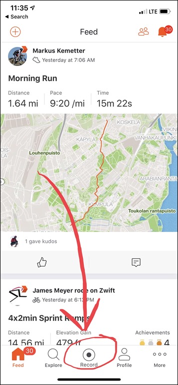
1) Open the app
2) Tap the ‘Record’ button as if to start a ride
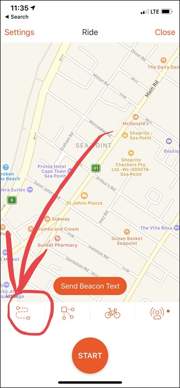
3) Click the Routes icon (lower left one)
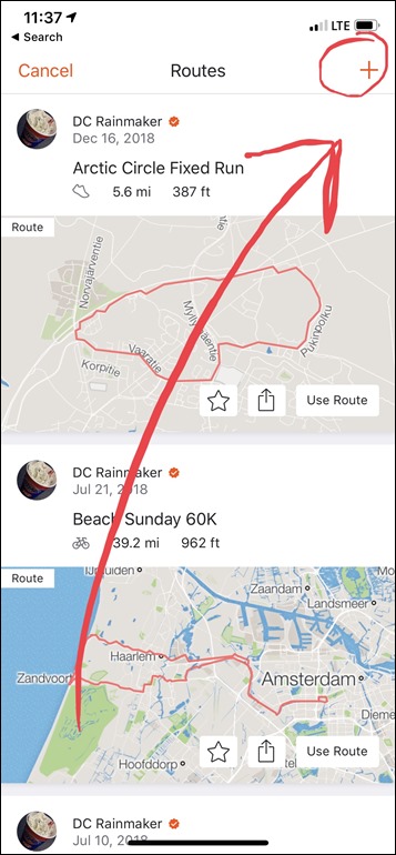
4) Click the + in the upper right corner of the routes page
5) Change the route type if desired between run or ride
6) Tap the pencil icon
7) Swig-zag-wag your finger around the map like Karate Kid
8) Wait a few seconds, magic route appears.
9) Give the route a title and save it.
Wait, you wanted a visual demonstration of those 9 steps? No problem. Here we are at the beginning of opening the Strava app and then tapping the Record button, after which you hit the routes button.
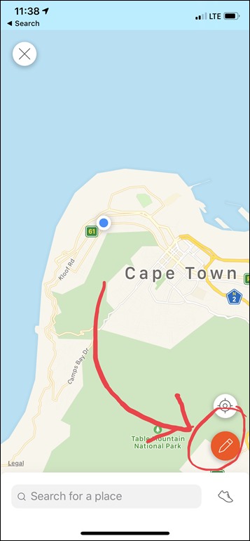
Next, whack that “+” icon in the upper corner to create a new route. Then, decide whether you want a running route or cycling route. You can tap the little shoe (or bike) in the lower right corner to change it.
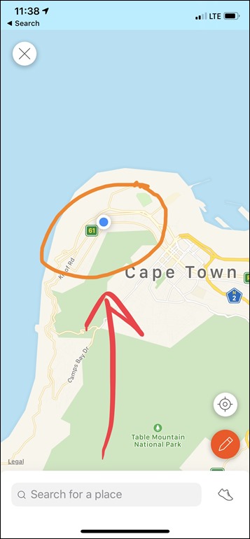
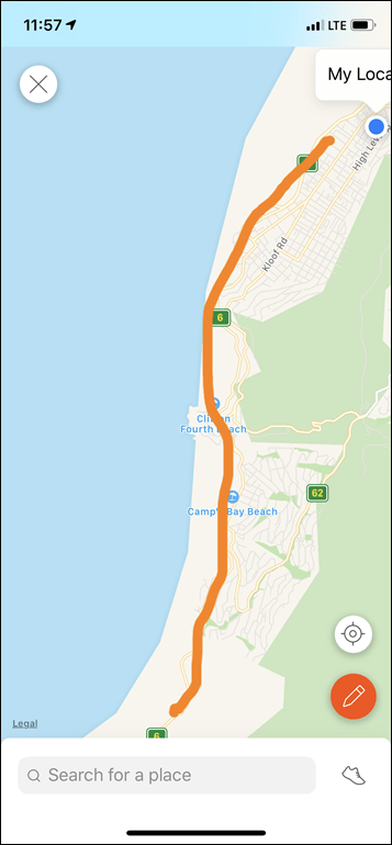
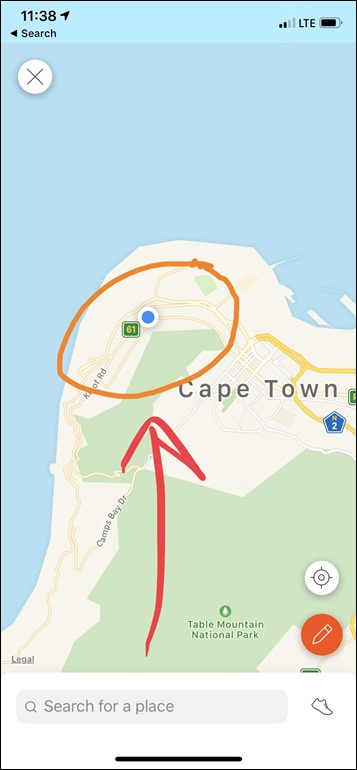
Next, you’ll see a blue dot on where you are, but that doesn’t have much bearing on your routes. Instead, if you want to move the screen somewhere else you can. Either way, once done hit the pencil icon, and then simply draw (for example) a circle using your finger, like this (in orange):
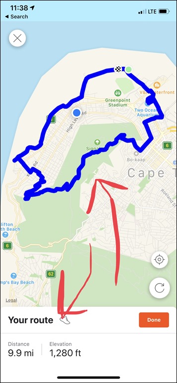
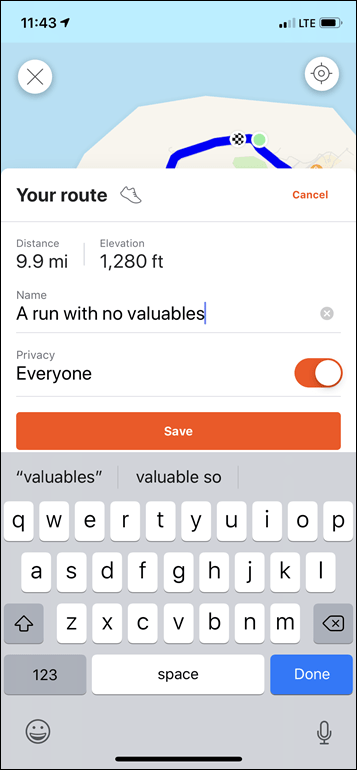
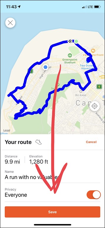
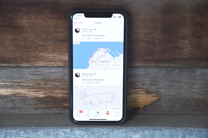
A few seconds later it’ll create a route automatically that roughly follows what you proposed via your finger expertise. You can then give it a name and change the privacy settings on it. After which, you’ll hit save. The route then shows up in your routes list like other routes.
And if you’ve got 3rd party devices like those from Garmin, Wahoo, Sigma, Karoo, and many others – it’ll automatically show up on those devices depending on how you have those devices/apps configured.
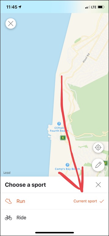
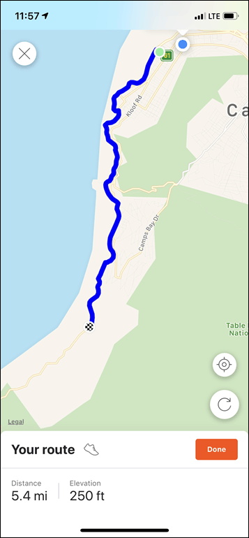
So, what about point to point routes? Yup, you can do those too. But, you have to do it in one swipe. I don’t see any way to edit a route after I’ve done one finger swipe:
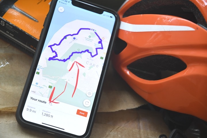
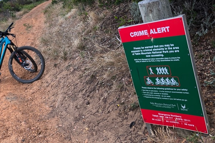
And that gets to what I see as the most problematic issue with the beta: No satellite mode. As you may have noted by my title above – this leads to tricky route creation. Here in Cape Town, for example, I’d want to specifically avoid off-road trails while running (or riding) alone. It’s simply not safe:
But I can’t really easily see what are areas I want to run or ride with the Strava routes feature, since it doesn’t allow me to toggle between map view and satellite view. And since the maps data here isn’t terribly accurate, even the non-coastal run (according to Strava) is actually a very nice coastal beach run in reality, while the part through the green is very much a giant mountain (and the green sorta implies a park).
I totally get that the security concerns of one area don’t apply to all, but the reality is that in virtually all my route planning anywhere in the world, I toggle satellite view constantly to see what kind of areas am I going through. Farmland? Industrial wasteland? Nudist colony? All things potentially spotted on satellite view. Maybe.
(Note: For more complex routes, I continue to use this method/app here instead.)
It’s cool stuff:
Of course, this is a beta, and one that Strava reportedly fast-tracked in under two months from initial solo developer concept to the widespread beta we see today. So it’s likely that we’ll see more changes to it in the future. My top three would be:
A) Allow more than one swipe
B) Allow manual edits
C) Allow switching into satellite mode
I’m sure there’s other recommendations people have as well – such as choosing routes that aren’t hilly, or perhaps are specific to on-road/off-road type scenarios.
Still, I think this is the best new feature we’ve seen from Strava in years. Admittedly, it’s about the only new non-security/rebranding feature we’ve seen from Strava in years – so the bar is kinda low. If comments on past posts are any indication – people are waiting for not just one new Strava feature, but a dozen of these. Hopefully this being merely February, we’ll see many more of these types of creative and useful features added to the platform over the course of 2019.
With that – thanks for reading, and have a great weekend!
FOUND THIS POST USEFUL? SUPPORT THE SITE!
Hopefully, you found this post useful. The website is really a labor of love, so please consider becoming a DC RAINMAKER Supporter. This gets you an ad-free experience, and access to our (mostly) bi-monthly behind-the-scenes video series of “Shed Talkin’”.
Support DCRainMaker - Shop on Amazon
Otherwise, perhaps consider using the below link if shopping on Amazon. As an Amazon Associate, I earn from qualifying purchases. It doesn’t cost you anything extra, but your purchases help support this website a lot. It could simply be buying toilet paper, or this pizza oven we use and love.



Thank you for the post! In the other article you post to related to more advanced routing the android app link is dead.
It’s like South Africa doesn’t have a police force and a judicial system. It’s nuts.
Nice feature but Summit remains well below the level I’d ever consider paying for.
Wow, did Strava just come out of a 3-year hibernation?
Not working here (Australia). I bring up the routes icon and it just gives me all my routes with a ‘cancel’ button on top right, no plus icon.
Have latest update of strava and the premium membership. Might be a staged rollout to different countries?
Have you enrolled in the beta program? For Android you can do it in the Play Store.
It’s there for me (Melbourne) but I can’t see how to make it useful. If I zoom out far enough to get a route in I don’t get enough control over where it goes..
Yeah, I agree on the zooming issue. To me that falls under my request of ‘allow multiple swipes’, so I can do it in chunks at an appropriately zoomed level.
I like the idea but it’s pretty much useless as it stands. My rides will normally be 100km or so and without better zoom functionality the best I could do was draw a much smaller route. And then what? I can’t see a way of getting it from Strava to my Garmin 520.
To get it onto your 520, download the Strava Routes CIQ app.
Thanks! Looks like a useful new feature.
My top 3 wishlist for Strava would be:
1. Create a system for mutual followers to send each other messages, both for paying and non-paying members of course.
2. Apply some basic sanity checks on uploaded runs, such as comparisons with world record times. The segment leader boards are often polluted by rides marked as runs and it would be more logical to include an automatic check instead of users having to flag other users’ activities.
3. Allow filtering the bar chart on the profile page by activity type. It just doesn’t make sense to add up running and cycling kms.
4. Automatically mark E-Bike-Rides as E-Bike-Ride and make a button for users to mark that on false tagged rides
5. Add discussion board / comments on segment page. That would be useful to describe a segment or to inform other riders about possible dangers etc.
They must have listened to your 2019 outlook chat with GP Lama and Des.
I paid for Strava when I loved their setup, but now that they’re dishing out ads to paying members, I’m out (does trading pennies for dollars make any business sense?). This feature is kinda useless anyway.
The funny thing is I noticed the in game ads on Zwift the other day, and despite being a paid member thought it added to the experience since races would have banner ads too :) Not OK on Strava though!
Which Summit? Any of the three, one particular one, or do you need the whole shebang? (Ah, market segmentation.)
That’s exactly what I was wondering too! I selected each one of the 3 groups to see if the new feature falls under one of them (to consider paying just that) but nope, no info.
An iPad would be the perfect device for point-and-drag route creation on the fly, i.e. EasyRoute (App Store link) but Strava *still* doesn’t support an iPad-specific layout in their app — instead they continue to pixel-double their iPhone app. ??♂️
No idea what Strava is doing with all that VC money. They must be keeping it in a pool to swim in, Scrooge McDuck-style.
Strava McDuck. ?
Try footpath app…works great on ipad
You should mention that if you sync the route to a Wahoo device, it won’t have turn-by-turn directions. Instead, it’s just a breadcrumb line on the map that you try to follow, but no instructions ahead of intersections. No matter how many summit features I’m paying for. The thread on the Strava support forum has literally hundreds of people asking for this.
Strava software development has truly jumped the shark. Their tech blogs has dozens of feel-good stories about how various interns are having a great time, and how all sorts of things are being “refactored”, but the bottom line is that they stopped adding relevant features years ago.
Yeah, unfortunately the whole Wahoo/Strava limitation has been that like forever. That’s honestly a split-fault thing.
A) It’s Wahoo’s fault for offloading legit turn by turn directions to 3rd parties
B) But it’s Strava’s fault for not matching other 3rd parties in providing that in the files to Wahoo.
Surely the routing software you plan route on needs to provide the TBT instructions. Because the maps on the GPS you are using may [actually quite often] have different mapping to your route planner.
My clubs use RunGo and RideWithGPS for audible turn by turn directions. It would be great if Strava could come close to their functionality. They could have improved their web route builder to the point of being usable instead of turning to a new useless shiny object.
I would add to the list of requirements for this feature the ability to start and finish at a set point. In the scale I need to fit my run in, my finger isn’t exact enough to set the start and finish locations accurately enough.
Also, you can add a route by going into your routes page in your profile, without the need to go through the record route Ray mentioned.
Agreed. Tried the routing feature but could not get it to start and finish where I wanted. It looks promising but needs some refinement.
Great walkthrough!
For iOS users I can strongly recommend Footpath. Basically it’s exactly what the new Strava builder is doing including your improvement suggestions. It’s currently the best that you can get for iOS (I tested them all, seriously)
Exporting the route as a file needs an in app purchase but it’s only a few bucks per year and I think it’s toally fair
This actually looks heavily inspired by a route planning app I made called Footpath (footpathapp.com, mentioned by another commenter above). We introduced route planning with your finger back in 2013.
Some possible back story on the Strava feature: link to twitter.com
Awkward… ?
Solid app, been using since first beta. Works great for routing
Keep watch on patent filings. You have limited time to file a prior art objection! ?
But seriously… probably the killer app feature is the database of routes, correlated to athlete profiles and their related history. One could easily imagine routes chosen based on training goals, similar pace, similar athletes by age or sex or interest, frequent distances run, etc. A smart enough system would address the needs of most users.
Great stuff! But no idea how to get it on my Polar Vantage without going the long export/import route. Any ideas anybody?
I was all excited when I saw Strava had updated it’s route planning, ‘Finally the route planner is out of beta and hopefully no longer dreadful to use’ I thought. But no, it’s still in beta after many years of frustrating its users. Meanwhile Strava boast how they built this mobile feature in a few months.
I wish i had seen this when I was running in a new area today!
Had to just wing it and stick to an out and back to get the time/distance ok.
I think your list of things it needs is spot on. Tried it tonight and the routing in a single swipe is tricky in a built up area as it tends to choose the weirdest routes. Manual edit would let you fix this though.
This has just taken all the skill out of ‘pictorial routes’ (ie Dick pics via Strava)
This was my first test… a massive C&B. I can confirm it works well. ;)
Must be an Aussie thing!
I’m happy to see that Strava is awakening from a multi-year product feature hibernation. This is a nice addition, especially if it’s using Strava data of popular segments instead of Google “Snap To Road”. For runners, I’m assuming that we will have to take our phones with us for guidance once we go out the door, right?
Hoping garmin does this on mobile (already good on desktop) and offer it free in connect…will marginalize this feature as allot of strava folks have garmin devices that do the routing anyway
Not sure why it wasn’t mentioned in the comments, but you can actually create routes on the fly with the Garmin Connect mobile app. In a way, it actually works better than what Strava has to offer (select start point, select direction (or random), give the desired length and you get a route based on that). In particular, you can immediately use that route for navigation on your watch.
Yeah, the only challenge with the Garmin option is you don’t really have any control over it from a direction standpoint. It’s always a loop and it’s always either East/West/North/South/random. So for cases where I know roughly where I want to go route-wise, and want the app to simply choose the most well travelled route, it doesn’t work at all.
Yes, I guess the mix of both functionalities would be perfect. Or at least some ‘drag-and-modify’ for the created route on Garmin…
Ray, thanks for super fast review. I just played with this feature only yesterday.
There is another way of launching Route Builder on Android Menu->Profile->all the way down to Routes->top right +
However, my major concer is the use of Strava Heatmaps. For running I find them very polluted with:
– races which are often on purposely closed roads
– other activities, mostly rides and hikes
– including old activities on roads which are closed or unavailable
I already posted this on Strava blog, with possible solutions, but no reaction so far.
You all know Komoot? Allows you to create routes and has curated as well as non-curated suggestions.
Best thing is it can differentiate between different sports, so the route between points will different depending on whether you want to run, MTB or road cycle.
Tested the cycling routes for my home town, Pittsburgh, Pennsylvania, USA. Pittsburgh is v hilly, and tough to navigate (famous local saying: O you can see it from here, you just can’t get there). The results puzzle me — the routes created seem to not adhere to the local Strava cycling heat-map. In any case, I strongly recommend NOT using the routes created by finger-sliding, as on every route I created there are sections that are never ridden by anyone with local knowledge due to dangerous conditions.
Additionally and more broadly, the scale of the map used for input makes the feature close to useless for 1-hour-plus rides.
I will continue to consult Strava heat-maps when looking for routes in unfamiliar locales.
Great piece
Hello, did you try the new system to create routes in the Suunto App ?
It’s a great piece ! Easy to use, fast to sync !
You can even sync a new route during an activity :D
This is cool. Man, wish they did not imitate instagram with their picture zooming as I hate to have to hold to zoom.
To be honest, since I discovered „Komoot“ I never used Strava route builder again. Komoot gives me a much more detailed choice of bike types and more information about road conditions etc. Some popular segments are copied to Komoot as well, so you can easily make a tour out of your favorite segments.
For Strava route builder I would like to focus more on segments, eg. choose a bunch of segments and the route builder creates a nice route out of that. Something that could work on the phone as well.
Nice to see the innovation – but the features no good to me until I can build more complex routes. The one click start stop doesn’t make sense on the small map you get on a smartphone.
There’s no evidence that they actually snap to heatmap data. It would be great if it did, and I could tell because it would not route me into random cul de sacs or have me meander through a hotel parking lot, doing an out-and-back within the lot, to cut a corner while adding distance. It’s just a dumb gimmick to try to trick more people into paying.
Both Bicycling and Wired’s articles indicate it uses heat maps, with the Bicycling magazine including exact quotes from Strava: link to bicycling.com
“…said senior product manager Graham Keggi, adding that this mobile tool uses Strava’s heat maps—more than 1 billion activities and 13 trillion data points collected worldwide—to craft the best possible route for your chosen activity.”
That doesn’t mean it won’t do dumb things – as I outlined in the post. But it does seem to do some heat-map based routing, even if it is clearly blending (for example) running and cycling at present, and likely weighting your proposed finger route slightly too heavily over heatmaps.
I’d like to see some kind of demonstration of how it snaps to heatmaps. They must have test cases to show themselves it works. For now it looks to me like they’re being dishonest. It’s obviously been a goal they’ve had, based on the tool they used to provide for using heatmaps to edit openstreetmaps. But for now it seems to be at best an exaggeration of their functionality. Usually your reviews test product claims, so that I’m surprised to see you taking their word for it.
Here’s the relevant heatmap. Needless to say it was a long enough route I couldn’t possibly exercise enough control to avoid this.
Odd, yeah, it’s definitely doing it partially in my area here – but not in others. So for the routes I tested, it does seem to snap to the most popular bits.
Where it seems to go wrong though is the deviation it permits from the original finger track. Meaning that it seems to take my finger swipe a bit too literal/exact. Rather than saying ‘Oh, I get what you mean, but this street 5 blocks over is much better.’
Of course, it’s beta.
I wonder if it’s tricky to calibrate the sensitivity of snapping to the heatmap to different areas. The heatmap might be a lot more powerful in the Bay Area where there are a bazillion users than in a college town in the middle of the country.
Yeah, hopefully we’ll see quick iterations on it. I wonder if that’s a backend tweak or a front-end app tweak. My bet is backend tweak, given it seems to take time to render the result after the finger swipe.
If you are trying to turn right there, it looks like it avoided the heavily trafficked (north?) route and used a slightly less hot route, but one that turns where you needed to. That is, if I am comparing your drawn and heat maps correctly.
I’m not sure what you mean by “turns where you needed to,” unless you’re assuming that the start/finish is at the Hampton Inn, which it is not. Maybe strava is suggesting that we use the Hampton Inn for a restroom break?
> Maybe strava is suggesting that we use the Hampton Inn for a restroom break?
You’re right to be suspicious… wait until self-driving cars suggest a short detour for a latte at Starbucks because Google gets a kickback. ;)
Nice article Ray! I’d like your opinion regarding Strava. This is the first meaningful feature they released in the last 3 years. Do you think Strava has an issue with current skills and competencies of their employees? I hope I’m wrong, but it gives me the impression they no longer master their technology and their platform. They can’t (or don’t want to?) add even the simplest features or changes asked for years by many paid users… It’s quite sad, give the potential of the platform :(
It’s a good question – and honestly, I’m not really sure. I know they’ve got some good and smart people there, I’ve met them. Motivated to do good stuff and have good ideas.
I question though whether leadership understands that, or understands the general level of anger people seem to have around Strava.
As I’ve alluded to before – while a lot of people (including myself) really do like Strava, there’s literally no topic I write about that gets more angry “What the heck is this company doing with my money’ type comments/tweets/etc than Strava. Not even close. By a landslide, Strava wins that.
Maybe some at Strava live in a bubble, maybe some just don’t care, I don’t know. But, what I do know is that eventually it’ll catch up to them. It always does to any company.
Thanks a lot for your answer – you gave an interesting hint I didn’t think of: the management has probably more than a share of responsibility in the current situation.
Regarding the skills of their employees, your answer reminded me one of their blog posts explaining the process behind the heatmap update (which was really interesting by the way!). The author explained that he cleared the data including… Obvious mistakes such as trainings recorded in train, plane or car. I was like wtf: so they have the technology, it’s just that they can’t or don’t want to use it on a daily basis! (or just that the heatmap was kind of a side project).
It’s quite saddening as they really had a nice advance over the competition and you’re right: if they don’t change, it will get back to them.
Indeed, if one has a chance, I really like their Strava Engineering blog: link to medium.com
Especially reading back – it goes through a lot of what they think about and design. Obviously, when folks are uploading some crazy number like hundreds of thousands (or more) activities per day there will inevitably be a weird one-off that nobody can account for until it happens, but by and large they do cover a ton of scenarios.
You can have the full desktop experience if Strava.com on iPhone by going to Strava.com in the chrome browser, including route making, heat maps, desktop activity analysis, etc. (safari login seems to force open the app).
Thanks for the detail. I could not test it after reading other articles. Totally agree with the three listed “needs” that are required to make it most useful.
In case you are wondering how to use this feature in Garmin or Wahoo (although wahoo has its own route feature in their built in app), there is an tutorial in this video (although this youtuber speaks in korean, but you’ll get how to from videos)
link to youtube.com
*In summary, download ‘strava IQ’ from garmin connect&
no kidding!
Is the distance based on trial and error?